


Våra favoritprylar just nu 🔥


Original price
1 000 kr
Original price
1 000 kr
-
Original price
1 000 kr
Original price
1 000 kr
Current price
649 kr
649 kr
-
649 kr
Current price
649 kr
Mystery Box Pike Medium
Kayakstore.se
In stock
Mystery Box Pike Medium – Ett välfyllt paket med japanska, skandinaviska och amerikanska beten, noggrant utvalda favoriter för gäddfiske. Perfekt ...
View full details
Original price
1 000 kr
Original price
1 000 kr
-
Original price
1 000 kr
Original price
1 000 kr
Current price
649 kr
649 kr
-
649 kr
Current price
649 kr
Sale

Original price
15 179 kr
Original price
15 179 kr
-
Original price
15 179 kr
Original price
15 179 kr
Current price
10 490 kr
10 490 kr
-
10 490 kr
Current price
10 490 kr
Raymarine Element 7 HV + Ultramax 12,8V LiFePO4 Isfiskepaket
Raymarine
In stock
Här har vi satt ihop ett komplett och smidigt paket för dig som vill ge dig ut på isfiske med riktigt vassa prylar från Raymarine. Du får deras spe...
View full details
Original price
15 179 kr
Original price
15 179 kr
-
Original price
15 179 kr
Original price
15 179 kr
Current price
10 490 kr
10 490 kr
-
10 490 kr
Current price
10 490 kr
Sale


Original price
79 kr
Original price
79 kr
-
Original price
79 kr
Original price
79 kr
Current price
65 kr
65 kr
-
65 kr
Current price
65 kr
Pepparkaksformar Fiske - Abborre Gädda Gös
Wiggler
In stock
Dessa pepparkaksformar är lika roliga att använda för både barn och vuxna, och det är ett kreativt sätt att umgås, spendera tid ihop som familj, oc...
View full details
Original price
79 kr
Original price
79 kr
-
Original price
79 kr
Original price
79 kr
Current price
65 kr
65 kr
-
65 kr
Current price
65 kr
Sale
Original price
8 049 kr
Original price
8 049 kr
-
Original price
8 049 kr
Original price
8 049 kr
Current price
4 049 kr
4 049 kr
-
4 049 kr
Current price
4 049 kr
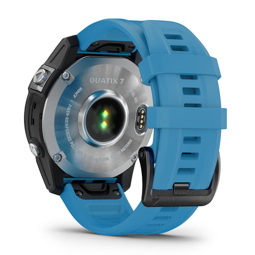
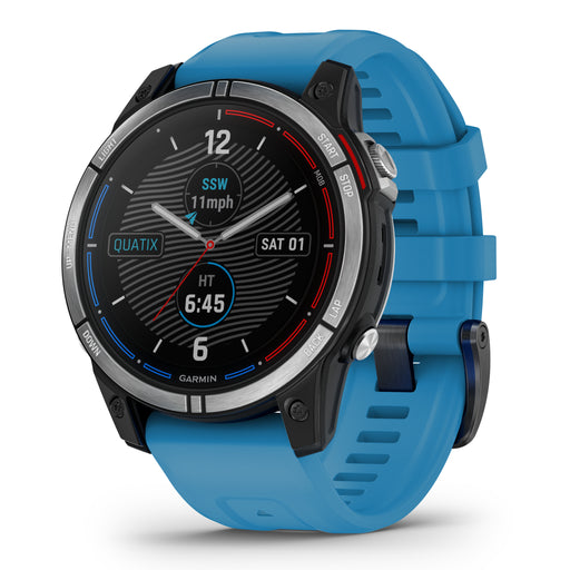
Garmin Quatix 7 - Standard Edition
Garmin
In stock
Made to order! Garmin's Quatix ® 7 smartwatch with GPS has all the functions you need both on the boat and on land. Battery life ...
View full details
Original price
8 049 kr
Original price
8 049 kr
-
Original price
8 049 kr
Original price
8 049 kr
Current price
4 049 kr
4 049 kr
-
4 049 kr
Current price
4 049 kr
Sale


Original price
1 799 kr
Original price
1 799 kr
-
Original price
1 799 kr
Original price
1 799 kr
Current price
1 349 kr
1 349 kr
-
1 349 kr
Current price
1 349 kr
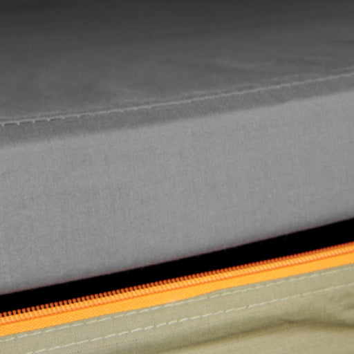
Dometic GO Hard Storage 50L
Dometic
In stock
Dometic GO Hard Storage 50L Dometic's PAC H50 Hard Storage lets you store essential outdoor gear in one place, making it easy to grab the shel...
View full details
Original price
1 799 kr
Original price
1 799 kr
-
Original price
1 799 kr
Original price
1 799 kr
Current price
1 349 kr
1 349 kr
-
1 349 kr
Current price
1 349 kr
Sale


Original price
599 kr
Original price
599 kr
-
Original price
599 kr
Original price
599 kr
Current price
569 kr
569 kr
-
569 kr
Current price
569 kr
Patriot Inuit -50°C Fodrade Stövlar
Patriot
Low stock
Den slitstarka designen kombinerar hållbarhet och komfort, medan det avtagbara fodret gör stöveln enkel att rengöra och anpassa efter väder och akt...
View full details
Original price
599 kr
Original price
599 kr
-
Original price
599 kr
Original price
599 kr
Current price
569 kr
569 kr
-
569 kr
Current price
569 kr
Sale
Original price
7 149 kr
Original price
7 149 kr
-
Original price
7 149 kr
Original price
7 149 kr
Current price
4 979 kr
4 979 kr
-
4 979 kr
Current price
4 979 kr
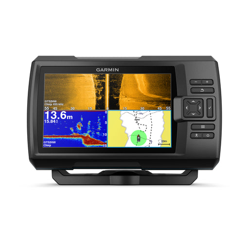
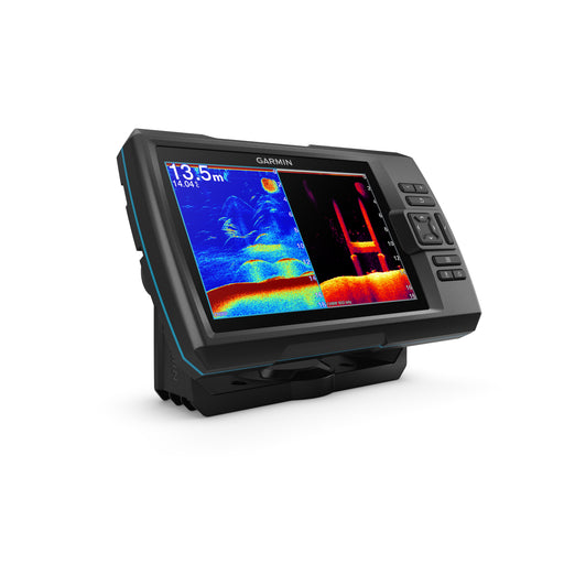
Garmin STRIKER™ Vivid 7sv, with GT52HW-TM transducer
Garmin
In stock
With the STRIKER Vivid 7sv fishfinder with transducer, you can see fish and structure in maximum detail when you choose the screen color, your l...
View full details
Original price
7 149 kr
Original price
7 149 kr
-
Original price
7 149 kr
Original price
7 149 kr
Current price
4 979 kr
4 979 kr
-
4 979 kr
Current price
4 979 kr
Sale
Original price
29 549 kr
Original price
29 549 kr
-
Original price
29 549 kr
Original price
29 549 kr
Current price
19 999 kr
19 999 kr
-
19 999 kr
Current price
19 999 kr
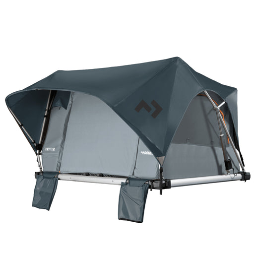
Dometic TRT120E Roof tent Ocean
Dometic
In stock
Dometic TRT120E An incredible roof tent that folds up in a few minutes thanks to electric operation (12V) and remote control (included). A g...
View full details
Original price
29 549 kr
Original price
29 549 kr
-
Original price
29 549 kr
Original price
29 549 kr
Current price
19 999 kr
19 999 kr
-
19 999 kr
Current price
19 999 kr
Sale


Original price
1 595 kr
Original price
1 595 kr
-
Original price
1 595 kr
Original price
1 595 kr
Current price
1 199 kr
1 199 kr
-
1 199 kr
Current price
1 199 kr
FUBUKI Boots Niseko 3.0 Low Sand
Fubuki
Low stock
Niseko 3.0 Low är uppföljaren till förra årets storsäljare från Fubuki, Niseko 2.0 Low. Den här versionen är en uppdaterad och förbättrad men till...
View full details
Original price
1 595 kr
Original price
1 595 kr
-
Original price
1 595 kr
Original price
1 595 kr
Current price
1 199 kr
1 199 kr
-
1 199 kr
Current price
1 199 kr
Sale


Populära kategorier


Original price
3 249 kr
Original price
3 249 kr
-
Original price
3 249 kr
Original price
3 249 kr
Current price
2 799 kr
2 799 kr
-
2 799 kr
Current price
2 799 kr
Garmin Striker 4 Portabelt Kit
Garmin
In stock
CHIRP-tekniken skickar ett svep av frekvenser, vilket ger förbättrad objektseparation och tydligare bottenkonturer, även vid höga hastigheter. För ...
View full details
Original price
3 249 kr
Original price
3 249 kr
-
Original price
3 249 kr
Original price
3 249 kr
Current price
2 799 kr
2 799 kr
-
2 799 kr
Current price
2 799 kr
Sale


Original price
4 399 kr
-
Original price
4 399 kr
Original price
4 399 kr
4 399 kr
4 399 kr
-
4 399 kr
Current price
4 399 kr
Deeper CHIRP+3 Power Bundle
Deeper
In stock
Deeper CHIRP+ 3 Power Bundle är fullspäckat med smarta funktioner som gör fisket enklare, effektivare och mer precist. Med avancerad CHIRP-teknik f...
View full details
Original price
4 399 kr
-
Original price
4 399 kr
Original price
4 399 kr
4 399 kr
4 399 kr
-
4 399 kr
Current price
4 399 kr


Original price
9 999 kr
-
Original price
9 999 kr
Original price
9 999 kr
9 999 kr
9 999 kr
-
9 999 kr
Current price
9 999 kr
Rapala StrikeMaster Maven 40V Combo 200mm
Rapala
Low stock
Den borstlösa 40V DC-motorn ger jämn och pålitlig prestanda även i tjock is. Jämfört med tidigare modeller är Maven 25 % mer kompakt och upp till 2...
View full details
Original price
9 999 kr
-
Original price
9 999 kr
Original price
9 999 kr
9 999 kr
9 999 kr
-
9 999 kr
Current price
9 999 kr

Original price
1 099 kr
Original price
1 099 kr
-
Original price
1 099 kr
Original price
1 099 kr
Current price
849 kr
849 kr
-
849 kr
Current price
849 kr
Rapala 13 Fishing The Snitch Descent Ice Combo 25" LH Flex Core
Rapala
In stock
Rullen är byggd med en robust grafitram och utrustad med en spole som möjliggör snabb frikoppling. Det ger dig full kontroll över släpphastigheten ...
View full details
Original price
1 099 kr
Original price
1 099 kr
-
Original price
1 099 kr
Original price
1 099 kr
Current price
849 kr
849 kr
-
849 kr
Current price
849 kr
Sale


Original price
339 kr
-
Original price
339 kr
Original price
339 kr
339 kr
339 kr
-
339 kr
Current price
339 kr
Patriot Inuit -30°C Fodrade Stövlar
Patriot
Low stock
Den lätta men slitstarka konstruktionen gör stöveln bekväm att bära även under längre turer, medan det avtagbara värmefodret gör att du enkelt kan ...
View full details
Original price
339 kr
-
Original price
339 kr
Original price
339 kr
339 kr
339 kr
-
339 kr
Current price
339 kr


Original price
29 799 kr
Original price
29 799 kr
-
Original price
29 799 kr
Original price
29 799 kr
Current price
21 979 kr
21 979 kr
-
21 979 kr
Current price
21 979 kr
Garmin Panoptix PS22-IF isfiskekit
Garmin
In stock
Isfiskekitet inkluderar en 7-tums ECHOMAP™ UHD2-plotter som erbjuder skarpa, tydliga bilder med både LiveVü™ Forward och LiveVü™ Down-ekolodslägen...
View full details
Original price
29 799 kr
Original price
29 799 kr
-
Original price
29 799 kr
Original price
29 799 kr
Current price
21 979 kr
21 979 kr
-
21 979 kr
Current price
21 979 kr
Sale


Original price
17 339 kr
Original price
17 339 kr
-
Original price
17 339 kr
Original price
17 339 kr
Current price
12 499 kr
12 499 kr
-
12 499 kr
Current price
12 499 kr
Lowrance Eagle Eye 9 med Live-givare
Lowrance
In stock
Med denna Lowrance enhet, Eagle Eye 9, kan du se hur fiskarna reagerar på dina beten direkt på skärmen, vilket gör att du kan planera ditt fiske m...
View full details
Original price
17 339 kr
Original price
17 339 kr
-
Original price
17 339 kr
Original price
17 339 kr
Current price
12 499 kr
12 499 kr
-
12 499 kr
Current price
12 499 kr
Sale
Original price
7 099 kr
Original price
7 099 kr
-
Original price
7 099 kr
Original price
7 099 kr
Current price
2 999 kr
2 999 kr
-
2 999 kr
Current price
2 999 kr
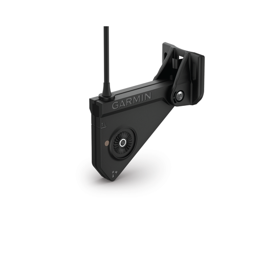
Garmin Panoptix Livescope LVS12
Garmin
In stock
Garmin Panoptix Livescope LVS12 !The affordable alternative for easy-to-interpret real-time sonar images! For those of you who...
View full details
Original price
7 099 kr
Original price
7 099 kr
-
Original price
7 099 kr
Original price
7 099 kr
Current price
2 999 kr
2 999 kr
-
2 999 kr
Current price
2 999 kr
Sale


Marknadsledande i Skandinavien på Kajaker, Sportfiske & Marinelektronik
Vi på Kayakstore.se är marknadsledande i Skandinavien på Kajaker, Fiskekajaker, Sportfiske, Marinelektronik samt Fisketillbehör. Hos oss hittar du ett av Sveriges mest omfattande och bästa sortiment av högkvalitativa varumärken inom branschen, såsom Hobie, Raymarine, Native, Torqeedo, Lowrance, Garmin, Shimano, MEGABASS, Grundéns, m.fl.
Möt Felix Frey, grundaren av Kayakstore.se och ett välkänt namn inom sportfiskebranschen. Med sin stora passion och internationella tävlingserfarenheter inom sportfiske har han och hans team skapat Kayakstore.se - Sveriges ledande webbutik för sportfiske. Få personlig service och utforska de bästa varumärkena inom sportfiske och kajakpaddling hos oss.
Oavsett om du är en professionell sportfiskare, passionerad entusiast eller nybörjare inom fiske och kajaker kan vi erbjuda den perfekta fiskeutrustningen för att du ska kunna ta dina upplevelser på vattnet till nya höjder. Vi har allt för dig som älskar att vara ute på sjön och i naturen!

Köp din Fiskekajak online hos Kayakstore.se
Köp din Fiskekajak eller Kajak online hos på Kayakstore.se, eller besök vår butik i Linköping. Upptäck det bästa inom fiskekajaker, kajaker, kanadensare och kanoter i Sverige - din pålitliga e-handel för ditt nästa fiske- och outdooräventyr!
Vi på Kayakstore är ledande i Skandinavien inom kajakpaddling samt sportfiskeprylar, där vi erbjuder ett stort sortiment av premiumprodukter från ledande varumärken. Hos oss kan du utforska allt från Sportfiskekajak från Hobie, till Paddelkajaker från Jackson och Bonafide.
Vi samarbetar med några av de bästa inom kajak- och fiskebranschen för att kunna erbjuda dig de bästa produkterna, som kan ta ditt fiske till nya höjder. Lita på vår expertis och handplockade utrustning och njut av fler framgångsrika fisketurer!
Välkommen in till oss för att utforska vårt sortiment idag. Vi ser framemot att visa dig varför Kayakstore.se är det bästa valet för sportfiske och kajakpaddling i Sverige.

700m² fullproppat med äventyr
Om du befinner dig i närheten av Linköping är det ett måste att besöka oss på Låsbomsgatan 27. Vår imponerande butik sträcker sig till över 700 kvadratmeter och är fylld till bristningsgränsen med outdoor, marin och fiskeprylar. Här får du möjlighet att personligen utforska vårt omfattande sortiment, och verkligen klämma och känna på produkterna innan du gör ditt val.
Vi strävar efter att göra ditt besök till en upplevelse utöver det vanliga. Från det ögonblick du kliver in genom våra dörrar välkomnas du av en atmosfär som osar äventyr. Vårt kunniga och passionerade team står redo att guida dig genom vårt sortiment, ge personliga rekommendationer och svara på alla dina frågor för att säkerställa att du hittar exakt det du behöver för dina äventyr i naturen och på vattnet.
Vi ser fram emot att välkomna dig till vår butik och dela vår passion för utomhuslivet med dig. Välkommen till en upplevelse du sent kommer att glömma, hos oss på Kayakstore/ EXPLR!


